About Kaspi
ExploreKaspi — History and City Development
Kaspi is a town in Shida Kartli and the administrative center of Kaspi Municipality. It stands on the left bank of the Mtkvari (Kura) River, at the confluence with the Lechuri, in a landscape where the river valley opens into the Inner Kartli plain. Georgian reference dictionaries also describe Kaspi as a settlement in the Lechuri valley and note the presence of a railway station.
Early layers: a medieval town and a shift to a “large settlement”
Kaspi appears in historical summaries as a settlement with early medieval roots. Georgian encyclopedic narratives emphasize a major rupture in the 730s, when the Arab commander Marwan devastated the town so severely that urban life largely declined; later tradition preserves the idea that Kaspi was once a “city,” but became more like a large settlement in subsequent centuries.
Feudal era: the Amilakhvari connection
According to encyclopedic summaries, from the 15th century Kaspi became associated with the powerful noble family of the Amilakhvari, fitting into Kartli’s broader feudal landscape.
Connectivity: river, routes, and rail
Kaspi’s modern profile is strongly tied to its junction-like location: the town is on the Mtkvari with a railway station and sits close enough to Tbilisi to function as a practical node within Inner Kartli’s movement corridors.
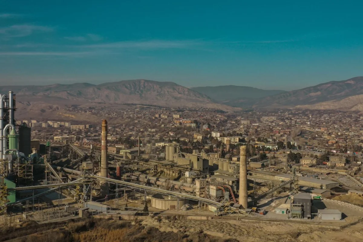
Industrial turning point: the Kaspi Cement Plant
One of Kaspi’s most city-shaping factors was cement production. The Georgian Encyclopedia notes that construction of the Kaspi Cement Plant began in 1927 (based on local limestone and clay resources) and the plant started operating in 1931, becoming a landmark of Georgia’s cement industry. This industrial core supported jobs, infrastructure, and an “industrial town” character typical of the 20th century.
1959: official town status
Although the settlement is much older, Kaspi officially received town status in 1959, as stated in major encyclopedic summaries.
Kaspi today: an administrative center with layered identity
Kaspi today combines two clear layers:
an historical layer tied to early medieval Kartli and later feudal ownership patterns;
a modern layer shaped by industry and connectivity (rail/river routes and proximity to Tbilisi).
FAQ
Q: Where is Kaspi located?
A: On the left bank of the Mtkvari (Kura), at the confluence with the Lechuri.
Q: When did Kaspi receive town status?
A: 1959.
Q: Why is the Kaspi Cement Plant significant?
A: Construction began in 1927 and the plant started operating in 1931; it became a key pillar of Georgia’s cement industry.
Sources
Encyclopedic & general overview
Wikipedia — Kaspi
https://en.wikipedia.org/wiki/Kaspi
Geography / basic facts (river confluence; rail station)
Wikipedia — Kaspi (RU page includes geography details in summary view)
https://ru.wikipedia.org/wiki/Каспи
Industrial history
Georgian Encyclopedia — Kaspi Cement Plant (construction 1927; operation 1931)
https://georgianencyclopedia.ge/ka/form/26073