



Martvili Canyon
Link copied
Photograph: Lasha ge (CC BY-SA 4.0), Jami430 (CC BY-SA 4.0), Peyman Zehtab Fard (CC BY 2.0)
A natural monument in the gorge of the Abasha, 45 kilometres from Kutaisi.
About
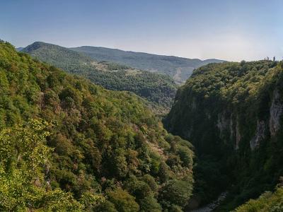
Martvili Canyon lies in Martvili Municipality, at the village of Gachedili; the river Abasha cut it into the limestone anticline of Abdati. The canyon is in the category of a natural monument, and the visitor centre stands at the entrance, in the village of Didi Inchkhuri. Kutaisi is 45 kilometres away.
Researchers give the length of the canyon as 2,400 metres, the depth of the cut as 20 to 30 metres and the width as 5 to 10 metres.
There are two routes on the site. By boat visitors cover a 300 metre stretch of the Abasha one way. The walking route starts at the visitor centre, makes a circle of 700 metres along the historic walkway of the Dadiani family, and takes in two bridges, three viewing platforms and a limestone staircase of 30 steps.
History
The best known stretch of the canyon is Oputskhole, also remembered as the bathing place of the Dadiani: by tradition it was part of the family summer residence, and their bathing place was laid out here.
According to legend, Giorgi Mtatsmindeli and David the Builder walked the 30-step limestone staircase of the Dadiani walkway. This is a legend and is not documented.
For visitors the canyon was fitted out with trails, viewpoints, bridges and a boat landing, and the Dadiani staircase and a water mill were restored; in 2017 it received 147,374 visitors.
Visit info
The canyon is open every day: in spring from 10:00 to 18:00, in summer from 10:00 to 24:00, in autumn from 10:00 to 19:00 and in winter from 10:00 to 18:00.
For the boat trip a child must be taller than 1 metre. On the walking route proper shoes and clothing are useful.
Safety
The path and the stairs can be wet and slippery. The water in the canyon stays very cold all year, and jumping from the waterfalls and swimming in high water have led to accidents.
Tip
May to September is the best time for the boat trip, when the river is a clear green and the bottom can be seen.
Sources
Nearby places
All places in the region
Nearby settlements