



Borjomi-Kharagauli National Park
Link copied
Photograph: Polscience (Public domain), Paata Vardanashvili (CC BY-SA 4.0)
The first national park created in independent Georgia, founded in 1995 in the centre of the country, on the Lesser Caucasus, across Samtskhe-Javakheti, Imereti and Shida Kartli. It covers 107,083 hectares, more than 1.5 per cent of Georgia. 75 per cent of it is untouched mixed forest, 64 species of mammals live here, and visitors have 12 marked trails, tourist shelters and camping sites.
About
Borjomi-Kharagauli National Park lies in central Georgia, on the Lesser Caucasus, south-west of Tbilisi, and stretches from the resort of Borjomi to Kharagauli. It takes in six municipalities, Borjomi, Kharagauli, Akhaltsikhe, Adigeni, Khashuri and Baghdati, and is one of the largest national parks in Europe. The park covers 107,083 hectares. Its administration also runs the Borjomi State Reserve (founded in 1935, 14,820.6 hectares), the Nedzvi Managed Reserve (founded in 1995, 8,992 hectares), the Ktsia-Tabatskuri Managed Reserve and the Goderdzi Petrified Forest Natural Monument. The highest peak of the park is Sametskhvario (2,642 metres); the best-known is Lomis Mta (2,198 metres), with a shrine of St George on top, from which on a clear day the Greater Caucasus and even Elbrus can be seen.
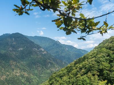
Forest is the park's main wealth: untouched mixed forest covers 75 per cent of the land, with fragments of relict Colchian forest, and about a quarter is taken up by subalpine and alpine meadows. Between 1,400 and 1,800 metres above sea level stand pure stands of spruce, fir and pine; all three forest-forming conifers, the oriental spruce, the Caucasian fir and the Caucasian pine, are Caucasian endemics. Georgian oak and hornbeam prevail in the lower belt and beech in the upper one, chestnut, a species of the Red List, is common, and the understorey holds rhododendron, yellow azalea, cherry laurel, holly and ivy. In the valley of the Likani river grows the yew, also on the Red List, some of the trees 8–10 centuries old. The park has more than 1,200 species of plants.
Some 64 species of mammals have been recorded, 11 of them Caucasian endemics and 8 on Georgia's Red List. The park is home to red deer, chamois, roe deer, brown bear, wolf, lynx, wild boar and wildcat, and to 20 species of bats. There are 217 species of birds, among them the Caucasian black grouse, and 30 species of reptiles live in the damp forests. Among the endemics are the Caucasian salamander and the Caucasian viper, and trout live in the rivers.
- Main routes
- Nikoloz Romanov Trail (3 days, 43 km, moderate); St Andrew the First-Called Trail (4 days, 54 km, hard); Likani Valley Trail (1 day, 7 km, easy); Kvabiskhevi Trail (1 day, 3 km, easy); Nakvalevi Trail (1 day, 13 km, moderate); Panoramas Trail (2 days, 34 km, hard); Zekari Pass Trail (2 days, 31 km, hard)
- Access notes
- The visitor centre is in the town of Borjomi, 23 Meskheti Street; a second visitor centre is in Kharagauli. Registration at one of the visitor centres is required before setting out on the trails
- Official info URL
- https://nationalparks.ge/ka/site/borjomi-kharagaulinp
History
In the Middle Ages the forests of the Borjomi valley belonged to the local nobility and were used mainly for hunting. In the nineteenth century, after Georgia became part of the Russian Empire, the emperor's brother Mikhail Romanov was appointed viceroy of Transcaucasia in 1862. He was so taken with the Borjomi valley that he decided to build a summer residence here, and in 1871 Alexander II gave his brother the whole Borjomi valley. Mikhail Romanov fenced off a large part of the forest and banned logging and hunting without permission, laying the foundation of the future park. In 1935 the Borjomi State Reserve was founded.
Borjomi-Kharagauli National Park was created in 1995 with the support of the World Wide Fund for Nature (WWF) and the German government, and was officially opened in 2001. It was the first national park in independent Georgia; it was also the first park in the Caucasus to meet the standards of the international Convention on Biological Diversity, and it joined PAN Parks, a network of European protected areas.
The Baku–Tbilisi–Ceyhan oil pipeline runs along the edge of the park and crosses its watershed. Environmental groups opposed its construction, arguing that a leak could damage the Borjomi ecosystem and that frequent landslides raise the risk of a breach. In August 2008 more than three square kilometres of forest in the park burned; Georgia called the fire an ecocide committed by Russia.
Visit info
Before setting out on the park's trails, visitors must register at one of the administration's visitor centres, in Borjomi or in Kharagauli. The Borjomi visitor centre is at 23 Meskheti Street; the visitor services specialist can be reached on 599 747 919. The centre is open all year, 09:00–18:00 on weekdays and 09:00–16:00 at weekends. From Tbilisi to the visitor centre it is 160 kilometres (about 2 h 15 min by car), from Kutaisi 130 kilometres (2 h 10 min), from Gori 79.7 kilometres (1 h 12 min) and from Batumi 277 kilometres (4 h 33 min). Minibuses to Borjomi leave from Didube metro station in Tbilisi every day, once an hour from 08:00 to 18:00; the train leaves Tbilisi central station at 7:05 and returns from Borjomi at 16:15. Minibuses to Kharagauli leave from the Okriba bus station at 9:00, 13:30, 15:30 and 17:00, and trains at 9:10 and 16:00.
The park has 12 marked trails, from one-day walks to five-day treks. The Nikoloz Romanov Trail (3 days, 43 km, moderate) runs from the Likani ranger post (900 m, 5 km from the visitor centre) by way of the Lomis Mta shelter and the Sakhvlari shelter (1,025 m) to the Marelisi ranger post (540 m). The St Andrew the First-Called Trail (4 days, 54 km, hard) starts at the Atsquri ranger post, passes the Amarati shelter (1,900 m) and Sametskhvario, and ends at Marelisi. The Likani Valley Trail (1 day, 7 km, about 4 hours, easy) climbs to the Chitakhevi ridge, its highest point at 1,446 metres. The Kvabiskhevi Trail (3 km, 3–4 hours, easy) lies 17 kilometres from the administration, about 30 minutes by car; in the valley stand the ninth-century church of Mariamtsminda and the ruins of the third-century Zemoti fortress. The Nakvalevi Trail (13 km, moderate) leads from Likani to Kvabiskhevi, and the Panoramas Trail (2 days, 34 km) is a loop from Atsquri. In winter there are two snowshoe trails.
A night in a shelter or cottage costs 30 lari per person (10 lari for schoolchildren and students) and a tent pitch 10 lari. The visitor centre rents out bicycles (35 lari a day, 25 lari for schoolchildren and students), tents (20 lari), backpacks (10 lari) and snowshoes. Horses can be hired from local people in Likani and Atsquri: in Likani 60 lari a day or 30 lari an hour, with a guide.
Safety
Keep to the marked trails. In the park it is forbidden to bring in firearms or anything dangerous to the environment, to bring in pets, to touch plants, rocks or fossils, to catch, chase or harm animals, to damage the infrastructure, to collect natural or cultural material without a permit, and to light fires except in the places set aside for them. Do not move fast when visibility is poor, in fog or in high scrub and grass. On the Nakvalevi Trail the descent into the Kvabiskhevi valley is relatively difficult, and on the Zekari Pass Trail the slope in places reaches 20–25 degrees. Brown bears and wolves live in the forest. For a night in the Chitakhevi shelter bring enough drinking water with you.
Tip
For a short visit the Likani Valley Trail is best: it can be walked in a day and shows untouched nature and views towards the Trialeti range. The Caucasian rhododendron and the orchids flower from May to June: on the Nikoloz Romanov Trail the slopes of Lomis Mta are bright with rhododendron in bloom in May and June. Snowshoe walks are possible from December to February. Near the Amarati shelter are the summer huts of shepherds, where you can see how they live. Wear trousers of rough cloth and high boots, and bring food for the trail and water.
Sources
- Borjomi-Kharagauli National Park — National Parks of Georgia
- How to get there — Borjomi-Kharagauli National Park
- Nature and culture — Borjomi-Kharagauli National Park
- Visitor guide — Borjomi-Kharagauli National Park
- Nikoloz Romanov Trail — National Parks of Georgia
- St Andrew the First-Called Trail — National Parks of Georgia
- Likani Valley Trail — National Parks of Georgia
- Borjomi-Kharagauli National Park — georgia.travel
- Borjomi-Kharagauli National Park — Georgian Wikipedia
- Borjomi-Kharagauli National Park — English Wikipedia
- Borjomi-Kharagauli National Park — Russian Wikipedia
- Borjomi-Kharagauli National Park — Wikidata
Nearby places
All places in the region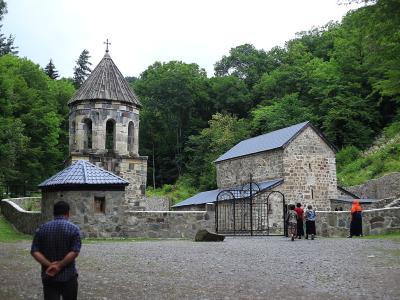
Places of the same kind
National Park — all places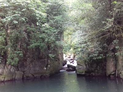
Nearby settlements