



Narikala Fortress
Link copied
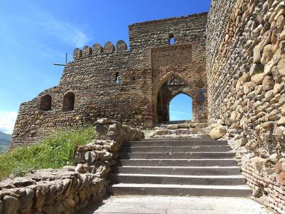
Photograph: Diego Delso (CC BY-SA 4.0), Supanut Arunoprayote (CC BY 4.0), Jesper Ahlin Marceta (CC BY-SA 4.0), Alexkom000 (CC BY 4.0), shankar s. (CC BY 2.0), Svjatosha (CC BY-SA 3.0)
A fortress on the Sololaki ridge above old Tbilisi.
About
Narikala stands on a high, narrow cliff at the eastern end of the Sololaki ridge, in the south-eastern part of Tbilisi. The Tsavkisistsqali runs below it, and the roofs of the old town and the valley of the Mtkvari open out beneath the walls.
The name Narikala appears in sources from the seventeenth century and means the inner fort, the citadel, in Persian. Before that the fortress was called Kala, Shuristsikhe, the fortress of the city of Tpilisi, and Maghlatsikhe.
The eastern enclosure measures roughly 70 by 70 metres and the western one 60 by 20; the walls are 1.5 to 2 metres thick.
History
The site was occupied long before the fortress: a dagger found here dates from the thirteenth and twelfth centuries BC.
The old Georgian chronicles, The Conversion of Kartli and The Lives of the Kings, attribute the fourth-century fortress to a Persian eristavi or pitiakhshi. The Conversion of Kartli names him as Kram Khuar Borzard and places the building in the second half of the fourth century.
From the second half of the sixth century, as Tbilisi grew stronger, the fortress mattered more.
Under Rostom, who reigned from 1632 to 1658, a wall was run from Khidisquri to the Kala fortress, dividing the city from the citadel and leaving behind the name Dabla Tsikhe, the lower fortress.
The Ottoman traveller Evliya Celebi described the place in the seventeenth century, though his figures are exaggerated: a circuit of some 6,000 paces, walls 60 cubits high, 70 buttresses and about 600 houses inside.
In 1795 the fortress was badly damaged in the battle of Krtsanisi, and in 1796 the sarajdars Parsadan and Stepane rebuilt the walls.
The earthquake of 1827 damaged the walls, the buttresses and the towers, and brought down much of the Stamboli tower.
In 1847 an explosion in a gunpowder store destroyed almost every building inside the fortress, among them the church of St Nicholas.
Restoration work was carried out in the 1970s and the 1980s. The church of St Nicholas was rebuilt between 1990 and 1997 on the old foundations.
Visit info
An aerial cable car runs up to Narikala from Rike Park, on the other side of the Mtkvari. Check the current timetable and fare with the cable car operator, and the terms of entry to the fortress locally.
Safety
Part of the fortress is a ruin, and it stands on a high rocky ridge. Keep away from the edges and hold on to children.
Tip
From the walls the old town, the sulphur bath quarter and the valley of the Mtkvari are all in one view.
Sources
Nearby places
All places in the region
Places of the same kind
Fortress — all places
Nearby settlements