


Khikhani Fortress
Link copied
Photograph: Boris Kuznetsov (CC BY 2.0), Kolkhi (CC BY-SA 4.0)
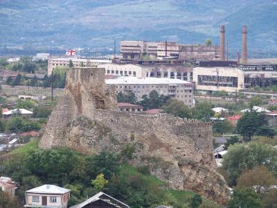
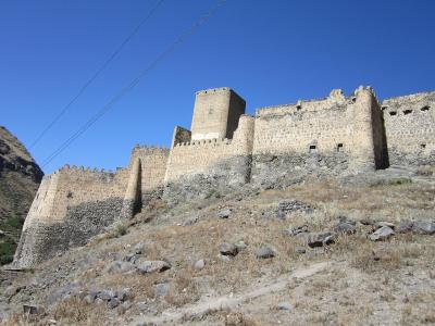
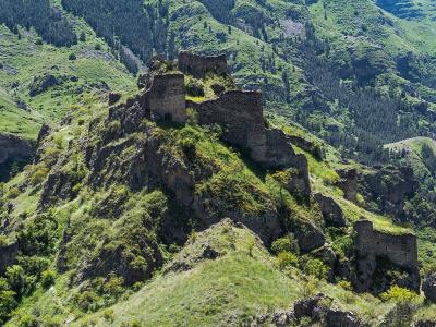
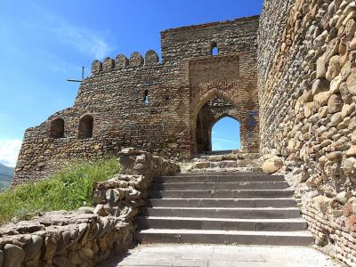
A medieval fortress in the village of Zeda Tkhilvana in Khulo municipality, at the head of the Skhalta valley, on a slope of Mount Khikhani atop a steep cliff at 2,236 metres, 110 kilometres from Batumi. Also called Khirkhati or Tamar's Fortress, it watched over the trade routes and in the eleventh–sixteenth centuries was the main residence of the Abuserisdze. Four towers, part of the walls and the remains of a church, a wine cellar and other buildings survive, and a fairly challenging 1.5-kilometre path climbs to it.
About
Khikhani, or Khirkhati, Fortress stands in the village of Zeda Tkhilvana in Khulo municipality, at the head of the Skhalta valley, on a slope of Mount Khikhani atop a steep cliff. It occupies a strategically very convenient spot with only one approach on foot, from the south-east. From its height of 2,236 metres above sea level it watched over the trade routes, and in time of war it sheltered Georgian nobles. The fortress covers several hectares, only a small part of which is level, the rest sloping and steep; some of its buildings survive in part, while others have been razed to the ground.
Several layers can be told apart in its masonry: the oldest of the tenth–eleventh centuries, a newer one of the seventeenth–nineteenth, the period of Ottoman rule. Today the remains of four towers, a church and the walls survive. The most damaged tower stands by the entrance, and before it five kvevri are set in the ground: the wine cellar of the fortress, whose rectangular "wine house" is up to 12 metres long and 4.5 metres wide. A second tower of several storeys stands 42 metres from the east tower, and three storeys can still be made out clearly in it. The north tower lies 180 metres from the second, and 133 metres from it stands the best-preserved, west tower, whose door is cut 2.85 metres above the ground; it was evidently reached by a wooden ladder.
A wall 33.5 metres long and 3 metres high runs north from the second tower, and in the area enclosed by it and a parallel wall are the remains of several buildings, among them a barracks-type building and a well 5.5 metres high and 1.5 metres across, probably a dungeon. Outside the walls, at the foot of the cliff, are the remains of a dwelling with a fireplace and small shelves. Tradition ties the building of the fortress to Queen Tamar, hence its other name, Tamar's Fortress. By legend there is a tunnel near the fortress, at Mtisubani, a secret path from Khikhani to Zarzma by which Tamar went to pray. The fortress was also described by Tedo Sakhokia.
- Construction period
- Oldest layer tenth–eleventh centuries, newer layer seventeenth–nineteenth (Ottoman period); most scholars date the fortress to the tenth–thirteenth centuries
History
The exact date of the building of Khikhani is unknown: its oldest masonry dates to the tenth–eleventh centuries, and most scholars date the building of the fortress to the tenth–thirteenth centuries. Historical documents give a large part in completing the construction to Bagula, wife of Tbeli Abuserisdze, while folk legends attribute the building to Queen Tamar. The stronghold watched over the trade routes and in war was an impregnable shelter for Georgian nobles, and in the eleventh–sixteenth centuries it was the main residence of the Abuserisdze, the eristavt-eristavi of Adjara.
The Ottomans later took the fortress, and its masonry also shows a layer of the Ottoman period, of the seventeenth–nineteenth centuries. In 1815 Selim Khimshiashvili, who fought against the Ottomans, held out in the fortress of Khikhani. Today the fortress is mostly in ruins; it was described by Georgian scholars, among them Tedo Sakhokia.
Visit info
Khikhani is 110 kilometres from Batumi, in Khulo municipality. A fairly challenging footpath one and a half kilometres long climbs to the fortress, starting at 1,800 metres above sea level and rising to 2,220 metres. Ask locally in Khulo about the road and transport to it.
Safety
The path is fairly challenging and climbs to 2,220 metres, where mountain weather can change fast, so sturdy shoes and warm clothes are needed. The fortress stands atop a steep cliff, so move carefully and do not climb the walls.
Tip
On the climb look for the remains of the four towers and the five kvevri by the entrance; in the best-preserved, west tower three storeys can still be clearly seen.
Sources
Places of the same kind
Fortress — all places