



Shkhara and the Shkhara Glacier Trail
Link copied
Photograph: Paweł Pieńkowski (CC BY-SA 3.0), Aleksey Muhranoff (CC BY-SA 3.0), Werderfan10b (CC BY-SA 3.0 de), Jules Laurens (Public domain), Limfjord69 (CC BY-SA 4.0)
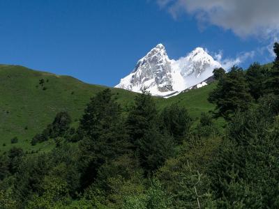
The highest peak of Georgia, 5,203 metres, the eastern anchor of the Bezengi Wall, first climbed in 1888 by Cockin, Almer and Roth, and a popular day walk from Ushguli to its foot at the tongue of the Shkhara glacier: 16 kilometres out and back, 540 metres of ascent, about 5 hours towards the sources of the Enguri.
About
Shkhara is a peak of the central part of the main watershed ridge of the Greater Caucasus in Upper Svaneti, on the border of Georgia and Russia (Kabardino-Balkaria), 88 kilometres north of Kutaisi: the highest point of Georgia and the highest summit of the main ridge, since Elbrus and Dykh-Tau stand on side ranges to its north; in the Caucasus it ranks third in height. The main summit is 5,203 metres, as refined by DGPS in 2010 by Peter Schoen and Boris Avdeev, though by some accounts it is 5,208; the western summit, at 5,068 metres, is a climbing objective in its own right, and the eastern is 4,866. By one reading the name means "nine" in Svan and refers to the many summits of the ridge, by another "striped". The peak is built of granites and crystalline schists; it is the eastern anchor of the Bezengi Wall, a ridge 11–13 kilometres long, with the Bezengi glacier descending on the north and the Shkhara glacier on the south, where the Enguri rises. The southern wall is 2,300 metres from base to summit and counts among the highest walls of the Caucasus and of Europe, the north face 1,500 metres; there is no low- or middle-grade route on Shkhara, the routes being graded 5A to 6A on the Caucasian scale, and the full traverse of the Bezengi Wall is held to be "Europe's longest, most arduous and most committing expedition".
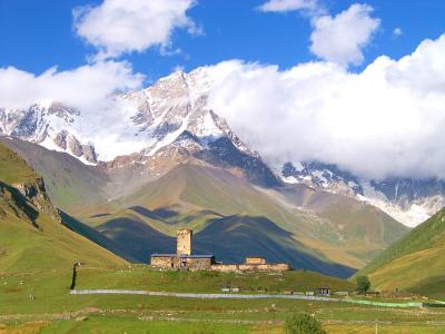
At the foot of Shkhara's southern slopes, at 2,200 metres, lies the UNESCO heritage village of Ushguli, from which a popular day walk begins: a jeep road follows the Enguri valley upstream towards the main ridge, and a small path then crosses a meadow and a wood and comes out at the edge of the moraine, about 300 metres from the foot of the glacier. The route is 16 kilometres out and back, from 2,122 to 2,430 metres with 540 metres of ascent, in about 5 hours; the glacier comes into view where the valley bends to the north-east.
- Difficulty
- Easy
- Route type
- Out & back
- Surface
- Mixed
- Access notes
- The path starts from Ushguli and follows the jeep road up the Enguri valley; a jeep shortens part of the way
- Safety notes
- Watch for falling rocks at the foot of the glacier; on the way you will cross a few small streams
History
The main summit of Shkhara was first climbed in 1888 by the Swiss Ulrich Almer and Christian Roth and the Englishman John Garforth Cockin by the north-east ridge from the Kabardino-Balkarian side, one of the principal ascents of the "golden age" of Caucasian mountaineering. Soviet climbers first ascended Shkhara in 1933, and in 1940 a then unprecedented traverse of some twenty summits of the main ridge of the Caucasus, Shkhara among them, was completed. In 2010 Peter Schoen and Boris Avdeev refined the height of the summit with a DGPS receiver; on the General Staff maps the western summit had wrongly been marked as the main one.
Shkhara is on the list of ten peaks for the Russian Federation's title of "Snow Leopard".
Visit info
The path starts from Ushguli, about 47 kilometres from Mestia; minivans to Ushguli leave Seti Square in Mestia in the morning once they are full. Follow the jeep road north from the village, up the Enguri; part of the way can be shortened by jeep, but jeeps stop where the path to Lake Namkuami branches off. The road is easy to follow; the last stretch is an unmarked path that turns off to the right where the road starts to climb in hairpins.
Safety
At the foot of the glacier, while taking pictures, watch for falling rocks; on the way you will have to cross a few small streams. The summit itself is reached only by a mountaineering expedition.
Tip
Most of the way runs along a jeep road at the bottom of the valley, so the walk is easy; the views of Shkhara are its reward. The way back from the glacier is the same as the way in.
Sources
Nearby places
All places in the region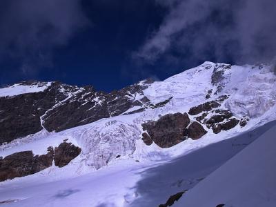
Places of the same kind
Trail — all places
Nearby settlements